Description
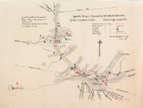
RARE 1906 Colonial British New Guinea Large Map. The Summit of Mt Albert Edward.
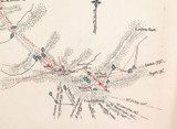
Super rare, the very first detailed map of Mt Albert Edward, unable to find another for sale or in any archives. 100% genuine & not a reproduction. A Sketch Map by C A W Monckton dated 06 (1906). NOTE C A W Monckton was the very first non native White man to climb Mt Albert Edward. The Printer is unknown. The Sketch map depicts Summit of Mt Albert Edward. Also noted is that the scale is 1 mile to 2 inches, Camps shown as a red dot, track taken in red scattered line & Native Tracks in solid red, lakes in blue, streams in solid black. To the left of the map it gives a brief description of the summit. Large folding map hinged to acid free white board. Looks far better than the photos depict. Measures 50cms x 37cms. Some minor tears along the fold lines & to the edges, some small losses along the fold lines, some minor foxing & marks. Will be posted flat to avoid damage.
Local Brisbane pick-up welcomed. Always happy to combine postage where possible & practical. HNCO are not responsible for import duties or customs charges. This is the buyers / importers responsibility.
_gsrx_vers_854 (GS 7.0.18 (854))


