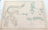
RARE c1860 LARGE “WEEKLY DISPATCH ATLAS” MAP of CELEBES & MOLUCCA ISLANDS.

$95
Condition:
Used
Shipping:
$8 (Fixed Shipping Cost)
Current stock: 0
Description

Description

These maps originally appeared in the Weekly Dispatch newspaper from 1856 to 1862 & were drawn and engraved by B.R. Davies, John Dower, T. Ettling, J.W. Lowry, and Edward Weller. They were reissued between 1863 and 1867 by Cassell, Petter and Galpin and then published collectively as Cassell's Atlas. The plates were acquired by G.W. Bacon & Co., and reissued in 1876 under the title Bacon's New Quarto Atlas.
 
Measures 46.5cms x 33.5cms. Very nice condition considering it’s age, some minor foxing & marks. The rear is blank. Will be posted rolled in a tube.
Reviews

Reviews (0)

Be the first to review this product.
Additional Info

Additional Info

Condition:
Used
Shipping:
$8 (Fixed Shipping Cost)

Related Products